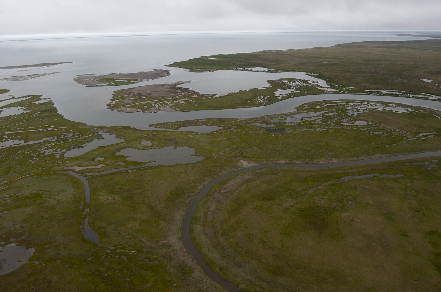
The coast of Bering Land Bridge National Preserve, 2012. Photograph by Neal Herbert. Flickr.
Roughly sixty thousand years ago, our ancestors began to disperse out of Africa. It’s difficult to know exactly which routes we took around the planet, or the precise timing of when we first reached new areas, because the fossil record is very patchy and it is often hard to tell from the archaeological evidence exactly which branch of hominins they were left by. So most of our understanding of humanity’s expansion comes from studying the genetics of indigenous populations living around the world today. By analyzing the DNA, and being able to estimate the rate at which mutations accumulate in the genetic code, we can work out how long ago different populations diverged from each other. Mapping this genetic variation around the globe allows us to work out when humans first arrived in different regions, and so enables us to follow the ancient migration paths.
The most surprising result to come out of these global genetic studies is that the human species is exceedingly uniform. Despite superficial regional differences in hair and skin color, or skull shape, the genetic diversity among the 7.5 billion humans living in the world today is astonishingly low. In fact, there’s more genetic diversity between two groups of chimpanzees living on opposite banks of a river in Central Africa than there is between humans on opposite sides of the world. Human genetic diversity is greatest within Africa, however, so even if we had never discovered any fossilized bones or early archaeological evidence and had only the DNA of modern humans to go by, it would still be clear that we all originated in Africa and spread from this birthplace. Moreover, the genetic studies suggest that humanity around the world today descends from a single exodus event out of Africa, rather than multiple waves of migration, and probably from no more than a few thousand original migrants.
Modern humans, Homo sapiens, first entered the Arabian Peninsula during a regional climatic shift to wetter conditions and a greening of the area, either by walking north across the Sinai peninsula or by taking a more southerly route by raft across the Bab el-Mandeb Strait. As our ancestors began to spread into Eurasia we encountered other species of hominins that had already left Africa much earlier.
As the first human migrants reached each new area their population grew and their descendants continued the dispersal. The region now covered by Iraq and Iran acted as a major dispersal hub, with migration streams heading up into Europe, across the rest of Asia, and into Australia and the Americas. It seems likely that humans first headed east, following the southern margin of Eurasia to India and Southeast Asia; an early offshoot from this path took humans into Europe around 45,000 years ago. The eastward migration split into two routes either side of the Himalayas, like a river flowing around a rock, with one path heading north across Siberia and eventually into the Americas, and a second taking a southerly route across Southeast Asia toward Australia. The spread through southern Asia seems to have been relatively quick, possibly due to the similarity in climate with our ancestral home in sub-Saharan Africa, and we reached Southeast Asia and China around 50,000 to 45,000 years ago.
From the Indochinese Peninsula, we crossed into New Guinea and reached the southern tip of Australia by about forty thousand years ago.
With global ocean levels over one hundred meters lower than today owing to ice age conditions, the shallow seas around Indonesia were exposed as dry land. The Indonesian archipelago became part of an extension of Southeast Asia known as Sundaland, and Australia, New Guinea, and Tasmania were all united as a single landmass called Sahul. These two lands faced each other across a narrow sea studded with chains of islands, which helped our migration into this southeastern corner of the world.
The slow wave of dispersal eventually reached the northeastern tip of Eurasia, and it is here that the ice age conditions proved most crucial for human migration: they gave us our route of entry into the Americas. Today, the coasts of Russia and the U.S. are separated by the eighty-kilometer-wide Bering Strait, with the two Diomede Islands sitting right in the middle of that sea channel. During the last ice age, with the dropping sea levels, the land of Siberia and Alaska would have extended to reach toward each other, like the outstretched fingers of Adam and God painted by Michelangelo on the ceiling of the Sistine Chapel, until eventually they touched and the two vast continents of Eurasia and the Americas were joined. This land corridor would have widened until, at the glacial maximum around 25,000 years ago, it stretched up to a thousand kilometers north to south. Although clear of ice sheets, the Bering land bridge would still have been a decidedly harsh environment: cold and dry, with dunes of silt that had been eroded by the glaciers and blown in the wind. The land bridge was little more than an Arctic wasteland, but dotted with enough hardy vegetation to support animals—woolly mammoths, ground sloths, and steppe bison, as well as the saber-toothed tigers that preyed on them.
Humans made it across this land bridge into America sometime after twenty thousand years ago. But other animals had already made the crossing in the opposite direction into Eurasia during an earlier ice age, some of which would become crucial to civilizations through history. Both the camel and horse had evolved in North America and crossed into Eurasia along the Bering land bridge, subsequently dying out in their birthplace.

After walking across the land bridge into Alaska, humanity worked its way down through the Americas as the ice sheets receded. They crossed the Panama Isthmus into South America around 12,500 years ago, and had reached the very southern tip of the continent within another millennium. Humanity had encompassed the globe.
Then, around eleven thousand years ago, as the world warmed again after the last glacial maximum and sea levels rose, the Bering land bridge once again disappeared beneath the waves. The connection between Alaska and Siberia was severed, and the Eastern and Western Hemispheres were cut off from each other. Lasting contact was not made again between the peoples of the Old World and the New for another sixteen thousand years, until Columbus set foot on the Caribbean islands in 1492. Genetically similar, but living in different landscapes with access to different plants and animals, these two isolated populations of humanity formed civilizations independently from each other but remarkably similar in their domestication of crops and livestock and the development of agriculture.
That this global expansion took place during the punishingly cold climate of the last ice age is perhaps surprising, but it is in fact these very icehouse conditions that enabled us to accomplish this. The growth of the northern ice sheets drew so much water out of the oceans that the dropping sea levels exposed great areas of the continental shelves. It is the Ice Age that allowed us to simply walk across dry land to Indonesia, cross the narrow sea into Australia, and crucially make our way along the Bering land bridge into the Americas. Lower sea levels also meant that there was a much greater area of land to live on—an additional 25 million square kilometers, roughly the equivalent of present-day North America.
But alongside providing the conditions that enabled humanity to spread across the globe, past ice ages have had other far-reaching implications for the molding of the landscape we inhabit and the course of our history.
Glaciation had profound implications for the reshaping of North America’s geography and the subsequent history of the United States. Here the extensive ice sheet diverted the course of the mighty Missouri and Ohio Rivers, and when the glaciation thawed these rivers continued to flow along what had been the edge of the ice sheet. Today they meet the Mississippi in a huge Ψ shape and offer easy east–west transport right across the interior of the continent. The Missouri in particular reaches over two thousand kilometers west to the Rocky Mountains. It was this river, previously diverted by the Ice Age, that carried the explorers Lewis and Clark most of the way toward the Pacific coast in 1804, and enabled the establishment of an American presence across the huge tract of Louisiana and the Northwest Territories. Other rivers too were diverted by glaciation, such as the Teays and Saint Lawrence; without these river transportation routes around the Appalachian Mountains, the original thirteen colonies might have remained confined to the Atlantic seaboard.
It’s on the other side of the pond, however, that we find perhaps the clearest example of the influence of the ice ages on history.
Half a million years ago, Britain was not an island. It was still part of continental Europe, physically connected to France—like conjoined twins—by an isthmus running between Dover and Calais. This land bridge was a continuation of the hump-shaped geological structure known as the Weald–Artois anticline that stretches from southeast England to northeast France, formed of layers of rock buckled upward in the same tectonic upheaval that created the Alps when Africa slammed into Eurasia.
The land bridge between England and France was eroded away to sever this connection, and this seems to have occurred in a sudden, catastrophic event. Sonar maps of the English Channel distinctly reveal an unusually straight and wide valley on the seafloor, containing streamlined islands and long, kilometer-wide eroded grooves—clear signs of a huge flood of water coursing over the ground.
As we have seen, during our current era of pulsating ice ages, glaciations have caused the global sea levels to drop over one hundred meters. This allowed the shallow continental shelf around the North Sea and the Channel basin to emerge as dry land. During the ice age around 425,000 years ago (five ice ages before the most recent glaciation) a vast lake of water became trapped between the Scottish and Scandinavian ice sheets and the thirty-kilometer-wide ridge of rock then still linking England and France. This lake was filled with meltwater from the ice sheets as well as the discharge from rivers like the Thames and Rhine.
And with no outlet to escape through, the water rose and rose, until inevitably it began to spill over the top of the land bridge. These colossal waterfalls scooped out vast plunge pools on the channel floor and gouged backward through the barrier until this natural dam collapsed. The entire trapped lake emptied itself as a catastrophic megaflood, widening the gaping breach in the barrier and carving the landforms on the floor of the Channel we can see with sonar today. This first megaflood 425,000 years ago is thought to have been followed by a second event around 200,000 years ago, and between them they wore away what is now the Strait of Dover, leaving the white cliffs as the stump of the former isthmus. With the subsequent thawing after each ice age and the rise in sea levels during interglacial periods, this passage formed the English Channel.
Britain had become permanently cut off from Europe.
.")
The formation of the English Channel has had profound ramifications through history for Britain, as well as for Europe as a whole. The Channel has served as a natural defensive moat, protecting Britain throughout European history. The last full-scale invasion, the Norman Conquest of 1066, occurred almost a thousand years ago. Britain was close enough to trade and remain intimately involved in the politics of the Continent, but shielded at the same time.
Throughout the constant squabbling, conflicts, and shifting borders of continental Europe, Britain has largely escaped the ravages of war on its own home soils and been able to remain distant and insulated, only choosing to intervene when it was in its interests.
In the seventeenth century, for instance, it was spared the devastation of the Thirty Years’ War, which began as a conflict between Catholic and Protestant European states and ravaged much of Central Europe, causing huge population losses—over 50 percent in some regions from the resultant famines and disease. Safe behind its natural moat, Britain’s situation contrasts in many ways with that of Germany, bounded to the north by sea and to the south by the Alps, but open on both sides through the European Plain. It is this vulnerability from the lack of natural defenses that explains much of the insecurity and military ambitions of the states in this region—the Holy Roman Empire, Prussia, and then Germany as a unified nation. With clearly defined natural boundaries and a relatively small extent, England achieved the early unification of feudal fiefdoms into a national identity. It has also been argued that it was this reduced threat of invasion and sense of security from external threats that allowed the progressive dispersion of power away from the autocratic monarch to a more balanced democratic system, beginning with Magna Carta in 1215 and leading to the parliamentary system in place today. What’s more, with no land border to defend, Britain’s military expenditure needed to be only a fraction of that of its continental rivals. Britain was instead able to focus its energies on building up and maintaining the Royal Navy.
Of course, it’s impossible to say with any certainty how European history might have played out had Britain not been an island. This is not the place for speculating on counterfactual histories, but thinking about the potentially profound alternative outcomes underscores the importance of geology in how we find the world today. If Britain were still linked to the continent by a land bridge, would the blitzkrieg sweep of the Wehrmacht across Europe also have defeated this last bastion of resistance against Nazi Germany? Would Britain have fallen to Napoleon’s Grande Armée in 1805, or would Spanish forces have invaded in 1588 (without the need for an armada)? And this isn’t just an issue for British sovereignty over history—it could be argued that the strong island nation has helped maintain a power balance across the whole continent by resisting invasion and preventing any one power from consolidating a European empire.
Adapted from Origins: How Earth’s History Shaped Human History by Lewis Dartnell. Copyright © 2019 by Lewis Dartnell. Available from Basic Books, an imprint of Perseus Books, a division of PBG Publishing, LLC, a subsidiary of Hachette Book Group, Inc.